



Metro+ (Madrid subway, buses)

Deskripsi Metro+ (Madrid subway, buses)
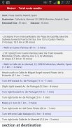
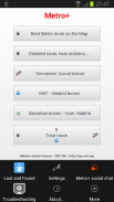
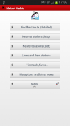
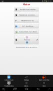
The most powerful app for finding the best route in Madrid (now also best Metro routes for several cities). Metro+ will make it easy for you: Metro Madrid, bus networks,.... Metro+ offers excelent information so that you cannot get lost. Besides, the "Total route" option collects all public transport obtaining the best itineray, even with walking instructions. You will be always supported by text and maps with a very user-friendly interface and providing the best user experience. Always up-2-date with downloadable DBs.
The main features are:
- Metro (several cities):
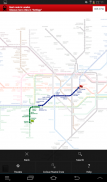
. Fast math calculations in order to find the best route between 2 stations. You can choose among several Metro networks: Madrid, Barcelona, New York, London, Paris, Rome, etc.... "Metro+" shows you the aprox. time to complete the route. Nearest Metro station search (not for all Metro maps).
The best route is calculated on the Metro plan tapping both stations (start and destination) or selecting them from the menu "Route". This section has got its own favourites and the best route can also be viewed on a list.
This option does not requiere Internet.
- Metro de Madrid:
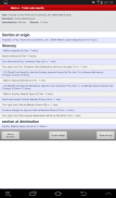
. Best route within the Metro de Madrid network. Just select start and end station, time and date (optional) and Metro+ will provide the best itineray. You can add favourites and widgets.
. Network status (+widget), disruptions and news
. 1 way fare
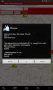
. Map that shows your location and all Metro de Madrid stations. Tapping one station, Metro+ shows you the distance between you and the selected station plus extra information, like pictures, etc... You can also enter a postal address or POI and the distance would be calculated between this entered location and the station. Optional: Metro+ can alert you with notifications of proximity alerts using vibration, LED and text notification when you approach the station (100 m.) or go away from this radious.
. List of stations in 10 km. radious from your location. You can tap a Metro station for more info.
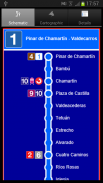
. List of all Metro lines (including Metro Ligero and Metro Sur). Tap a station for info.
. Fares
. Official maps
- Widgets: best route & lines status
- Cercanías (local trains):
. Official Renfe Cercanías app built-in in Metro+: timetable, best route, disruptions, news... (for Madrid and other spanish cities).
- Madrid EMT buses:
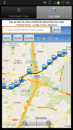
. List of all EMT lines, schematic departure & return maps with itinerary and timetable. Also the paths on a Google map
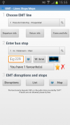
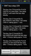
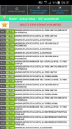
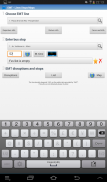
. Waiting times: Provided in real time for all the bus stops (thousands). Just enter the code/number stop and Metro+ will indicate what (line and destination) bus is next that is approaching. You can add favourites, view the picture of the stop, etc... Also you can see the selected stop on a map with traffic status. If you tap on the bus icon, Metro+ shows you the distance between you and the stop. If you enter a postal address or POI, the distance will be between this location and the stop. Optional: Notification of proximity alert when approaching the selected bus stop (100 m).
. EMT disruptions.
- Widget: waiting times for all stops.
. List that shows the nearest bus stops from your location (3 km.) + info of every stop.
. Map & all bus stops + info.
- Urban buses (with next arrival times and also widget) of localities within the "Comunidad de Madrid" like Móstoles, Alcorcón, Fuenlabrada, Alcobendas, etc...
- Suburban buses:
. All lines & maps, itinerary and timetable.
. Complete Info of every line.
. Next arrival times (also widget)
. Disruptions.
- Total route:
. Best route between two locations taking into account different public transports, waking, etc. You can add favourites and widgets from here. Also you can check the route on a map. Total route is the ultimate way to get the best and fastest route.
- Widget
- Map with bicycle lanes in Madrid.
- Spanish & English.
- Link to "Metro+" chat (Social network & Community for "Metro+" users).
- Lost and Found section
Aplikasi yang paling kuat untuk menemukan rute terbaik di Madrid (sekarang rute Metro juga terbaik untuk beberapa kota). Metro + akan membuatnya mudah bagi Anda: Metro Madrid, jaringan bus, metro .... + menawarkan informasi Excellent sehingga Anda tidak bisa hilang. Selain itu, "Jumlah rute" pilihan mengumpulkan semua transportasi umum mendapatkan itineray terbaik, bahkan dengan petunjuk berjalan. Anda akan selalu didukung oleh teks dan peta dengan antarmuka yang user-friendly sangat dan memberikan pengalaman pengguna yang terbaik. Selalu up-2-date dengan DBs download.
Fitur utama adalah:
- Metro (beberapa kota):
. Perhitungan matematika cepat untuk menemukan rute terbaik antara 2 stasiun. Anda dapat memilih di antara beberapa jaringan Metro: Madrid, Barcelona, New York, London, Paris, Roma, dll .... "Metro +" menunjukkan Anda aprox tersebut. waktu untuk menyelesaikan rute. Metro terdekat pencarian stasiun (tidak untuk semua peta Metro).
Rute terbaik dihitung pada rencana Metro menekan kedua stasiun (memulai dan tujuan) atau memilih mereka dari menu "Route". Bagian ini telah mendapat favorit sendiri dan rute terbaik juga dapat dilihat pada daftar.
Pilihan ini tidak requiere Internet.
- Metro de Madrid:
. Rute terbaik dalam jaringan Metro de Madrid. Hanya pilih awal dan stasiun akhir, waktu dan tanggal (opsional) dan Metro + akan memberikan itineray terbaik. Anda dapat menambahkan favorit dan widget.
. Status jaringan (+ widget), gangguan dan berita
. 1 cara tarif
. Peta yang menunjukkan lokasi Anda dan semua stasiun Metro de Madrid. Tapping satu stasiun, Metro + berisi jarak antara Anda dan stasiun yang dipilih ditambah informasi tambahan, seperti gambar, dll ... Anda juga dapat memasukkan alamat pos atau POI dan jarak akan dihitung antara ini memasuki lokasi dan stasiun. Opsional: Metro + dapat mengingatkan Anda dengan pemberitahuan dari tanda kedekatan menggunakan getaran, LED dan pemberitahuan teks ketika Anda mendekati stasiun (100 m.) Atau pergi dari radious ini.
. Daftar stasiun di 10 km. radious dari lokasi Anda. Anda dapat menekan stasiun Metro untuk info lebih lanjut.
. Daftar semua jalur Metro (termasuk Metro Ligero dan Metro Sur). Ketuk sebuah stasiun untuk info.
. Tarif
. Peta resmi
- Widget: terbaik dengan garis & Status
- Cercanias (kereta lokal):
. Resmi aplikasi Renfe Cercanias built-in di Metro +: jadwal, rute terbaik, gangguan, berita ... (untuk Madrid dan kota-kota Spanyol lainnya).
- Madrid EMT bus:
. Daftar semua lini EMT, keberangkatan skema & kembali peta dengan jadwal dan jadwal. Juga jalan pada peta Google
. Menunggu kali: Diberikan secara real time untuk semua berhenti bus (ribuan). Cukup masukkan kode / nomor berhenti dan Metro + akan menunjukkan apa yang (line dan tujuan) bus berikutnya yang mendekati. Anda dapat menambahkan favorit, melihat gambar berhenti, dll ... Anda juga dapat melihat halte dipilih pada peta status lalu lintas. Jika Anda menekan ikon bus, Metro + menunjukkan jarak antara Anda dan berhenti. Jika Anda memasukkan alamat pos atau POI, jarak akan antara lokasi ini dan berhenti. Opsional: Pemberitahuan kedekatan peringatan ketika mendekati halte bus yang dipilih (100 m).
. Gangguan EMT.
- Widget: waktu tunggu untuk semua berhenti.
. Daftar yang menunjukkan bus terdekat berhenti dari lokasi Anda (3 km.) + Info dari setiap berhenti.
. Peta & semua bus berhenti + info.
- Bus Perkotaan (dengan waktu berikutnya kedatangan dan juga widget) lokalitas dalam "Comunidad de Madrid" seperti Móstoles, Alcorcon, Fuenlabrada, Alcobendas, dll ...
- Bus Suburban:
. Semua garis & peta, jadwal dan jadwal.
. Info lengkap setiap baris.
. Kali kedatangan berikutnya (juga widget)
. Gangguan.
- Jumlah rute:
. Rute terbaik antara dua lokasi dengan mempertimbangkan angkutan umum yang berbeda, bangun, dll Anda dapat menambahkan favorit dan widget dari sini. Anda juga dapat memeriksa rute pada peta. Jumlah rute adalah cara utama untuk mendapatkan yang terbaik dan tercepat rute.
- Widget
- Peta dengan jalur sepeda di Madrid.
- Spanyol & Inggris.
- Link ke "Metro +" chatting (jaringan Sosial & Komunitas untuk "Metro +" pengguna).
- Bagian Lost and Found


